 |
> Central de reservas > Reserva de hoteles > Reserva de vuelos > Alquiler de autos > Ofertas de hoteles! |
> Guías turísticas > Mapas > El clima mundial > Foro del viajante > Contáctenos |
| |
| destinos |
| actualidad |
| foro del viajante |
| directorio |
| mapas |
| chat del viajero |
| clima mundial |
| postales |
| videos de viajes |
| reservar hoteles |
| vuelos baratos |
| alquilar un auto |
| ofertas de viajes |
| contáctenos |
About San José, Costa Rica
Weather, vacations, travel and hotels.
| Weather | Hotels | Maps of Costa Rica | Rent a Car | San José | Disponible en Español | Leave its opinion!
About San José - Costa Rica Each of the seven Provinces of Costa Rica are divided into Cantones, and each Canton is divided into several Districts. Population : 1.400.000 |
||
 Cantón 1: San José
Cantón 2: Escazú
Cantón 3: Desamparados
Cantón 4: Puriscal
Cantón 5: Tarrazú
Cantón 6: Asserí
Cantón 7: Mora
Cantón 8: Goicoechea
Cantón 9: Santa Ana
Cantón 10: Alajuelita
Cantón 11: Vasquez de Coronado
Cantón 12: Acosta
Cantón 13: Tibás
Cantón 14: Moravia
Cantón 15: Montes de Oca
Cantón 16: Turrubares
Cantón 17: Dota
Cantón 18: Curridabat
Cantón 19: Pérez Zeledón
Cantón 20: León Cortés Castro
History
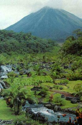
The city of San José has been the capital of the Province of San José since 1823. It is the place where most of the Costa Rican population is concentrated. Here, there are many public interest sites, such as museums, galleries, and entertainment places like restaurants, casinos, bars and nightclubs. In the countryside you'll find coffee, vegetables, sugar cane, beans, corn and ornamental plants.
Before Colombus came to Costa Rica, the territory of San José was occupied by the indigenous group called 'Huetares'. In 1561 Don Juan de Cavallón founded the city of Garcimuñoz in the Valley of Santa Ana. San José was founded in 1737 with the name of 'Abra de la Boca del Monte', between the rivers Torres and María Aguilar. They built a church honoring Saint Joseph.
General Description
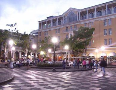 Compared to other Central American capitals, San José is more cosmopolitan, even North Americanized. There are department stores and shopping malls, fast-food chain restaurants, and blue jeans. It takes a day or two to start getting the real 'tico' feeling of the city. Perhaps the first sign of being in Costa Rica is the friendliness of the people. Asking someone the way will often result in a smile and a genuine attempt to help you out.
Although the city was founded in 1737, little remains from the colonial era. Indeed, until the Teatro Nacional was built in the 189Os, San José was a small, largely forgotten city. Today, the capital boasts several excellent museums, good restaurants, and a fine climate - the main attractions for visitors. But most visitors have a quick look at the museums, then go on to the national parks, rainforests, and beaches - tasty food and an agreeable climate can be found elsewhere in the country. Because Costa Rica's public transport and road system radiates from San José, the capital is often used as a base from which to visit the country's many attractions.
Although Costa Rica is known for trying to preserve the environment with one of the best national park systems in Latin America, the environmental effort is less evident in urban areas. In the late '90s, the phasing out of leaded fuel and the introduction of a vehicle emissions program (Ecomarchamo) were followed by a slight decrease in lead and carbon monoxide levels. However, air pollution, mainly from street traffic, remains a definite problem in the city. Central pedestrian areas and large parks make a welcome break from vehicle traffic.
Orientation
The city stands at an elevation of 1150m and is set in a wide and fertile valley known throughout Costa Rica as the Valle Central (Central Valley). The city center, where many visitors spend much of their time, is arranged in a grid. AlI the streets are numbered in a logical fashion, and it is important to learn the system because all street directions and addresses rely on it. This system is also applied in many other Costa Rican towns.
Perhaps the most interesting to downtown visitors is Barrio Amón, northeast of Avenida 5 and Calle 1, which has the best concentration of historical buildings, most of which tend to be residential or small commercial structures rather than major public edifices. East of Amón is Barrio Otoya, a less trendy version of Amón.
East of downtown at the canton Montes de Oca is the semiresidential barrio of Los Yoses, with an increasing number of firstcIass restaurants and hotels, followed by San Pedro, which is a major suburb in its own right and is where the main university is found, with the accompanying university-area ambience. Heading east on Avenida Central from central San José through Los Yoses, the traveler passes a traffic circle with a huge fountain - the Fuente de la Hispanidad and a local landmark. San Pedro begins beyond the fountain, and about 300m east of the fountain along Avenida Central is the San Pedro church, another important landmark.
West of the center is La Sabana, named after the biggest park in San José. Northwest of La Sabana lies Rohrmoser, which has many elegant addresses, including several residences of ambassadors, presidents, and ex-presidents. In the hills several kilometers southeast of La Sabana are the suburbs of Escazú, and Santa Ana, with many upper-class residential areas, country-clubs, golf-clubs, and hotels.
Regresar a la página anterior | Ir al inicio de Los Mejores Destinos